
Walk a Westmont Street Record
A sound Westmont street directory search separates ownership from evidence of residence. DuPage property cards identify a parcel, its situs, or physical location, and the owner or billing party shown for a tax year. Recorded deeds identify parties to land instruments. Neither source is a household roll. A directory or voter result may add dated evidence that a person used the address, but it still needs a second match.
- Enter the house number and street in DuPage Property Records Search. Save the PIN, situs, billing name, legal description, and tax year.
- Locate that PIN in the DuPage GIS Parcel Viewer. Check parcel lines, nearby lots, roads, and municipal limits.
- Use the Recorder's address index for recent instruments. If it misses, try the PIN or owner name in the right coverage period.
- Check voter and historical directory results as dated evidence. Match the street spelling and one more fact.
- Keep the source date and any gap. Never turn an owner name into an unsupported claim about an occupant.
Westmont Address Search Fields
County forms split an address into parts. The Recorder provides street number, direction, street, and city controls, while the PIN and document number also have separate components. GIS instructions say to remove PIN dashes. These details explain many false no-result screens.
| Key | Use | Caution |
|---|---|---|
| Address | Recent deed and parcel searching | Recorder coverage starts in 1995 |
| PIN | Match one parcel across systems | Online deed coverage starts in 1985 |
| Name | Find owner or deed party | Online deed coverage starts in 1961 |
| Legal description | Confirm an older parcel | More stable than a street label |
The public 105 N Park Street card is a municipal sample used to show the schema. It displays tax, assessment, transfer, and map navigation, but it does not represent every household.
Read a Westmont Parcel Card
The official Westmont sample property card shows how DuPage arranges its parcel fields.
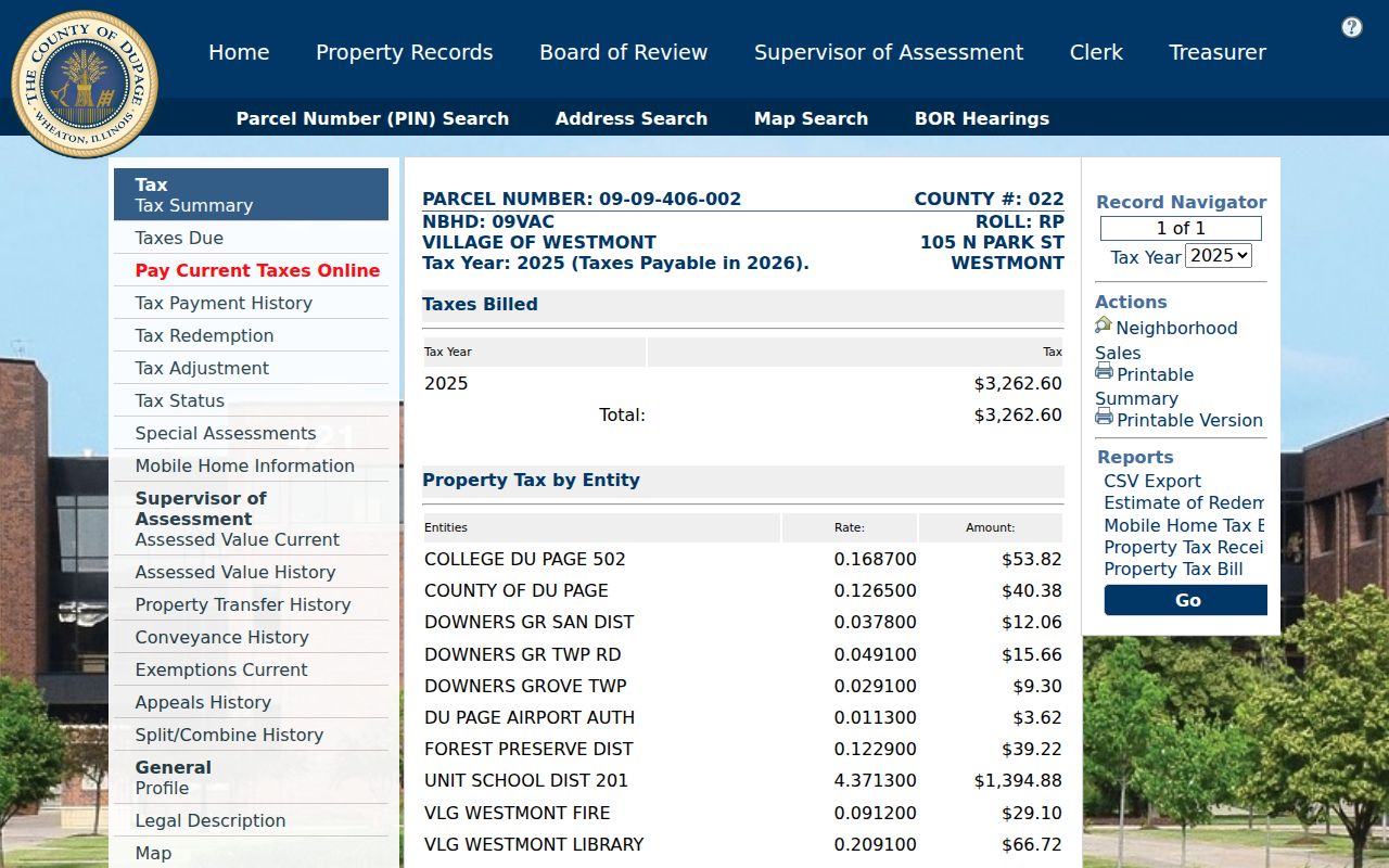
Carry the PIN, situs, legal description, and selected tax year into GIS and deed work. Billing information names a tax-card party, not all residents at that site.
Map Westmont Streets by Parcel
The DuPage GIS Parcel Viewer accepts partial street details, zooms to results, opens parcel popups, and supplies roads, streams, wetlands, floodplain, parcel boundaries, and historic aerial imagery. A documented buffer selects land around a source parcel, with 250 feet from the parcel edge as the default. Results can be exported, but listed owners remain tax-card parties rather than verified occupants.
Attribute search can begin with either a PIN or an address. The help material separates house number, direction, street name, suffix, and unit. Once a parcel is selected, neighboring parcels can be added and the chosen set can be exported or printed as a map. This is useful when the same road bends across municipal, postal, school, or sanitary lines. Keep the selection method with the export. A list produced by a 250-foot buffer is not the same as every parcel on the named street.
Save the map date, PIN, and chosen layers. Visibility changes with scale, and the viewer carries map disclaimers. The county also provides office and help routes when the viewer fails. For an immediate radius rather than the whole named road, the Westmont neighbors page explains the block workflow.
Search Westmont Deeds by Street
DuPage Recorder coverage differs by key: name searches begin in 1961, PIN searches in 1985, and property-address searches in 1995. Office research reaches 1839 to the present. A blank address result may reflect the index era, so change keys or call the Research Department at 630-407-5401.
The official Recorder index shows the name, address, PIN, document, type, and date routes.
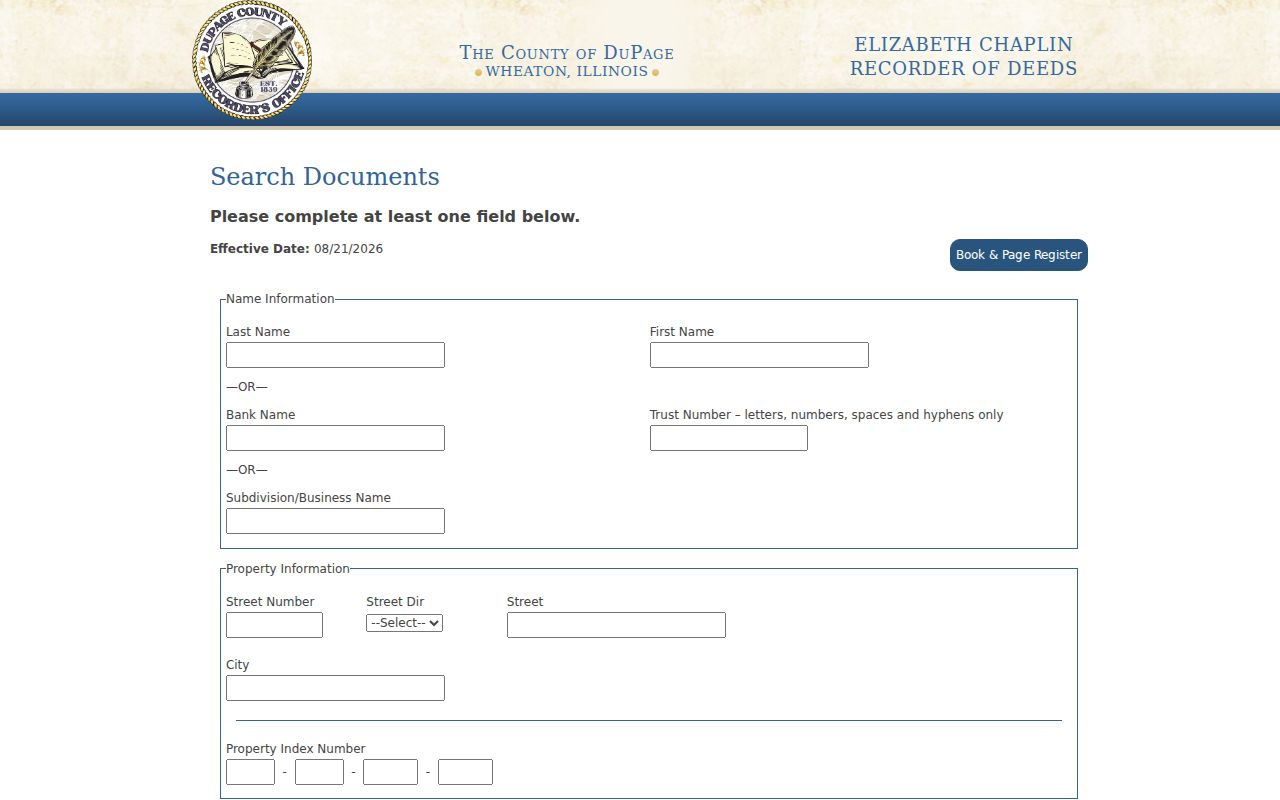
Capture the document number, type, grantor, grantee, filed and recorded dates, and legal description. A grantor gives an interest and a grantee receives one. Neither role alone proves residence.
Westmont Street Directory Sources
Official sources accept an address or related key, but each answers a different question and follows its own access rule.
| Record Set | Keeper | What It Shows | Access |
|---|---|---|---|
| Property card | DuPage property portal | PIN, situs, billing, tax, transfers | Free public portal |
| GIS parcel map | DuPage GIS | Boundaries, adjacent lots, aerials, layers | Free viewer |
| Recorded instruments | DuPage Recorder | Deeds, liens, plats, parties, dates | Online or in-office |
| Voter address search | DuPage Election Division | Registration and district data | Official form and election rules |
| Permits and concerns | Village of Westmont | Permit, inspection, code, and service context | Civic Access, 311, or focused FOIA |
The PIN joins parcel, map, tax, and deed data. Street fields connect municipal and election forms, but direction and suffix stay separate. Date every result because these systems update on different schedules.
Historic Westmont Street Names
Westmont records grew from a railroad settlement. Early sources may say Buffalo Trail, later Naperville Road, or Ottawa and LaSalle Trail, later Ogden Avenue and Route 34. The Chicago-Aurora railroad branch arrived in 1862 to 1864, and Gregg's Station is useful search vocabulary for early material.
The Village incorporated in 1921. Official history says original plats were laid out in the early 1900s and streets are basically unchanged, but that does not make an old intersection identical to a modern situs. The 1925-26 and 1927-28 directories use spouses, phones, cross streets, civic titles, and abbreviations. Preserve the printed form and verify it against a plat or legal description. No Westmont renumbering year was verified.
Older directory entries may identify an intersection instead of a numbered house. Work from the printed cross streets into a period plat, then compare the legal description in a deed. Telephone exchanges and spouse names can separate two residents who share a surname. The old phone number is a dated clue only. It should never be presented as a current contact. When an archive description and a page image disagree, keep both citations and ask the holding library to confirm the volume.
Westmont Streets Cross Many Lines
The official 2023 map shows six ZIP areas touching Westmont: 60514, 60515, 60516, 60523, 60527, and 60559. It also marks nearby villages, unincorporated DuPage, private streets, parks, boundary agreements, and roads that are not through streets. A Clarendon Hills, Downers Grove, Oak Brook, or Willowbrook postal label does not settle the municipal boundary.
Quick links place most School District 201 service north of 55th Street and describe a utility split around Cass Avenue. Tax cards can list township, fire, library, school, park, and sanitary bodies. These layers help distinguish places, but none replaces the PIN and Village limit.
Westmont Permits by Address
Village records add work and service history that county land systems do not hold. Community Development uses Civic Access for permits, while the Village identifies express permits, inspections, code enforcement, and an address-keyed 311 concern route. A permit can name a project, parcel, contractor, applicant, or inspection event, but the fields depend on the record and should not be guessed from a search result.
Westmont's current permit mix crosses several departments. The Clerk, Community Development, Fire Prevention, and Public Works right-of-way functions may each hold part of an address file. Selected express permits include roofing, window or door replacement, water heaters, HVAC work, and generators. Planning and zoning records also need a date because the zoning ordinance was comprehensively amended in August 2025 and received minor amendments in February 2026. Match the application date to the rule then in force.
Begin with the normalized street number, direction, name, and suffix. If the current portal does not show the period needed, send a narrow Illinois Freedom of Information Act request to the Village custodian. State the address, date range, department, and record type. County FOIA instructions specifically direct municipal property or municipal records back to the municipality, so a Westmont permit request should not start as a broad DuPage County request.
The Report a Concern route allows an anonymous submission, while an account is needed to track a response. The Village warns that submissions can become public records. Treat a complaint as an allegation or service request, not proof of a condition or a resident's conduct. Ask for the final inspection, disposition, or closed record when that outcome matters.
Keep permit facts separate from deed and tax facts. A person who applied for work is not necessarily the owner, and an owner is not necessarily an occupant. The value is in the dated property event. Pair that event with the PIN and legal description when the address could be ambiguous.
Limits of Westmont Street Records
A Westmont street directory cannot prove who lives or sleeps at an address. Property cards show parcel and billing data. Voter information is purpose-limited, and Village 311 tracks concerns rather than publishing a neighbor roll. Illinois Address Confidentiality Program participants receive a substitute address, while the program warns that it does not ensure confidentiality in property records.
- Parcel
- A mapped land unit identified by a PIN.
- Situs
- The parcel's physical location, distinct from its billing address.
- Plat
- A recorded map that divides and labels land.
- Directory entry
- A dated listing that may preserve old spellings and intersections.
Lawful use. Use Westmont address records for family, property, civic, or safety research. Never use them to stalk, harass, intimidate, or expose a protected person.